
Weather Forecasting using the MM5 website
By Steve Roti, 2001
What is the MM5?
The MM5 is a computer model of the atmosphere that predicts barometric pressure, wind velocity, precipitation, and lapse rate. As paraglider pilots, all of these variables affect our flying so the MM5 forecasts can be extremely useful in helping us decide where to fly.
The Pacific Northwest MM5 forecasts are produced twice a day by the Department of Atmospheric Sciences at the University of Washington. The MM5 forecasts currently feature a 36 km resolution domain that covers much of western North America and the northeastern Pacific, a 12 km resolution domain that covers Oregon, Washington, and southern British Columbia, and a 4 km resolution domain encompassing the western half of Washington State.
But before we jump into how to use the MM5, let’s define some terms that are necessary to understand in order to forecast soaring conditions.
Lapse Rate definitions
Lapse Rate: The change in temperature of the air with changing altitude.
Standard Lapse Rate: The average lapse rate found around the earth. 3.6 degrees F or 2.0 degrees C per 1000 feet.
Dry Adiatic Lapse Rate (DALR): The change in temperature a parcel of air undergoes due to expansion as it is lifted. 5.5 degrees F or 3 degrees C per 1,000 feet.
Moist Adiabatic Lapse Rate (MALR): The change in temperature a saturated air parcel undergoes as it is lifted. This lapse rate varies depending on the original temperature of the rising air, and averages about 3 degrees F or 1.7 degrees C per 1000 feet.
Stability: Unstable air occurs when the actual lapse rate is greater than the DALR, conditionally unstable air when the actual lapse rate is between the DALR and the MALR, and stable air when the actual lapse rate is less than the MALR.
Saturation: The state where the air reaches 100% humidity.
How to use the MM5 website
The MM5 website is located at: http://www.atmos.washington.edu/mm5rt/mm5.cgi
The MM5 URL shown above will display a web page with two panes: a lefthand pane titled “Page Navigation” and a righthand pane titled “Pacific Northwest MM5 Weather Forecasts”. In the righthand pane scroll down to the table titled “12 km Domain”. The best times to view the model are around 9:00 AM in the morning and 9:00 PM in the evening because that’s about when new forecasts become available. In the morning the “Initial Time” will end in 12 UTC and in the evening it will end in 00 UTC. In order to choose the correct “Forecast Hour”, remember that Pacific Standard Time (PST) in the winter is 8 hours behind Coordinated Universal Time (UTC), and Pacific Daylight Time in the summer is 7 hours behind UTC. Since I’m usually interested in the forecasts for early and late afternoon, when using “Initial Time” 12 GMT I choose “Forecast Hour” 9 and 12 and when using “Initial Time” 00 GMT I choose “Forecast Hour” 21 and 24.
Wind and rain forecasting
The “12 km Domain” table covers Oregon and Washington and some surrounding areas. The three forecast products that I use the most are:
- SLP, 10 m winds, topography or 925 mb temp (shows wind at ground level)
- 850 mb heights, temperature, winds (shows wind at 5,000′)
- 3-hour precipitation (shows rain)
Make your choice by clicking on the appropriate forecast hour to the right of the product name and you’ll see the chart you’ve chosen. Once you’re done viewing a chart you can change to another chart by using the Back button in your browser to return to the “12 km Domain” table to make another choice.
The wind charts are fairly easy to read once you identify the geo-political boundaries drawn in black. I find it easiest to identify the mouth of the Columbia River first, then follow the river east to find Portland and further east to find The Dalles (hint: it’s the small “v” where the river takes a brief detour to the south). The wind velocity is represented by arrows with barbs at the tail end. The wind direction is from the tail to the tip of the arrow, and the wind strength is indicated by the number and size of the barbs. A short barb indicates 5 knots, a long barb indicates 10 knots, and a triangular barb indicates 50 knots. Add up all the barbs on an arrow to get its total strength. Special case: a circle in place of a wind arrow means no wind (light and variable).
The precipitation charts are equally easy to read. Precipitation is indicated by colored areas with a color scale on the bottom of the chart showing how much rain is forecast for the 3-hour period. Generally speaking we want to see large clear areas for paragliding, but the coast is a special case where we can find reasonable flying conditions even if there are a few small colored areas along the coastal strip (“scattered showers”).
Lapse rate forecasting
Near the bottom of the “12 km Domain” table there’s a link titled “Soundings” — click that link and you’ll see a page titled “PacNW MM5 Forecast Soundings” with a map of available forecast locations. Then click on one of the red dots on the map — this will produce a type of lapse rate chart known as a Stuve diagram for the air temperature and dewpoint forecast above the chosen city at a particular forecast hour (the default forecast hour is 12). Depending on where I’m thinking of flying I choose an appropriate city.
- Hood River and The Dalles for the Gorge.
- Salem for the Willamette Valley.
- Astoria for the coast.
- Portland and Stampede Pass for the Toutle River valley.
- Redmond for Central Oregon.
The lapse rate charts are the most difficult MM5 charts to read. Briefly, the numbers on the left-hand side of the chart indicate pressure in millibars which corresponds to altitude. As an approximation, 1000 mb is sea level, 900 mb is 3,000 feet, 800 mb is 6,000 feet, 700 mb is 10,000 feet, 600 mb is 14,000 feet, and 500 mb is 18,000 feet. The temperature scale is shown on the bottom of the chart in degrees Celsius. The colored lines that make up the chart have the following meaning:
- The green lines are the dry adiabatic lapse rate (DALR) lines.
- The red dashed lines are the moist adiabatic lapse rate (MALR) lines.
- The purple lines are the saturation lines.
- The blue squiggly line is the dewpoint forecast.
- The red squiggly line is the temperature forecast.
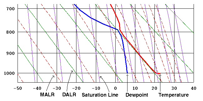
The slope of the temperature forecast line as it angles upwards from the ground indicates the potential for thermal production. If the temperature line parallels the nearest DALR line that means that thermals will rise along that line. The top of the thermal lift is usually at an inversion, a point on the temperature line where it makes a turn upwards or to the right with a slope steeper than the DALR lines.
If the temperature and dewpoint lines meet that indicates the likelihood of rain. If the temperature and dewpoint lines don’t meet, there may or may not be cumulus clouds depending on the relationship between the two lines. To determine whether cumulus clouds are likely at the chosen forecast hour, start at the bottom of the dewpoint forecast line and draw a line upwards parallel to the nearest saturation line until it intersects the temperature forecast line. If the intersection is below the inversion that indicates a potential for cumulus clouds with cloudbase at the altitude of the intersection. The reasoning behind this is that the ascending parcel of air takes its water content along with it as it rises from the ground, and it becomes saturated when it reaches the intersection with the saturation line. Further ascent will cause condensation and the formation of a cloud. In the example shown above, taken from a lapse rate chart for 2:00 PM on May 16 2000 in Portland, the cloudbase is forecast to be around 6,000 feet.
Reference Books
Understanding the Sky, Dennis Pagen, Sport Aviation Publications, 1992.
Cross-Country Soaring, Helmut Reichmann, The Soaring Society of America, 1993.
Northwest Mountain Weather, Jeff Renner, The Mountaineers, 1992.
Northwest Marine Weather, Jeff Renner, The Mountaineers, 1993.
The Audubon Society Field Guide to North American Weather, David M. Ludlum, Alfred A. Knopf, 1991.
The Weather Book, Jack Williams, Vintage, 1997.
Soaring Meteorology for Forecasters, Charles V. Lindsay and Stanley J. Lacy, The Soaring Society of America, 1976.
Meteorology and Flight, Tom Bradbury, A & C Black, 1996.
Other useful weather forecasting URLs
NWS Portland office: http://www.wrh.noaa.gov/portland/forecasts.html
Winds Aloft: http://www.awc-kc.noaa.gov/awc/awc-fd.html
Jet Stream: http://squall.sfsu.edu/gif/jetstream_pac_init_00.gif
Gorge (commercial): http://www.iwindsurf.com
Links to MM5 GFS extended run– Thanks to Steve Seibel
Soundings (go to hour 180):
http://www.atmos.washington.edu/mm5rt/rt/soundings_d2.cgi?GFSX+current_extendedOregon surface winds and 1 hour precip (goes to hour 84):
http://www.atmos.washington.edu/~ovens/wxloop.cgi?mm5d2_x_or_pcp1+///1Washington surface winds and 1 hour precip (goes to hour 84):
http://www.atmos.washington.edu/~ovens/wxloop.cgi?mm5d2_x_wa_pcp1+///1Larger region surface winds and 1-hour precip (goes to hour 84):
http://www.atmos.washington.edu/~ovens/wxloop.cgi?mm5d2_x_pcp1+///1Oregon surface winds and 3 hour precip (goes to hour 180):
http://www.atmos.washington.edu/~ovens/wxloop.cgi?mm5d2_x_or_pcp3+///3Washington surface winds and 3 hour precip (goes to hour 180):
http://www.atmos.washington.edu/~ovens/wxloop.cgi?mm5d2_x_wa_pcp3+///3Larger region surface winds and 1-hour precip (goes to hour 180):
http://www.atmos.washington.edu/~ovens/wxloop.cgi?mm5d2_x_pcp3+///3All products of extended run:
http://www.atmos.washington.edu/mm5rt/rt/extendedgfsinit.12km.html
MM5 home page:
http://www.atmos.washington.edu/mm5rt/